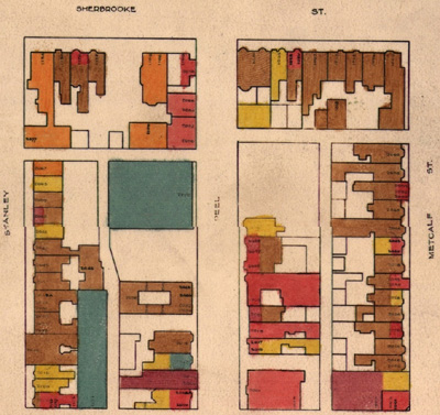
The Montreal Land Use Map (1949) is a colour map series, 70 plates in total, that represents the land use of Montreal in 1949. This set of maps were produced by the City of Montreal, City Planning Department in 1949. The land use categories are: residential, commercial, light industry, heavy industry, railway lands, parks and playgrounds, and public buildings. The originals are housed at the City of Montreal Archives, and were scanned in 2000.
Description
| Title | [Montreal Land Use Map (1949)] |
| Author | City of Montreal Planning Department |
| Date | 1949 |
| Documentation and Legend | Information for consulting the Montreal Land Use Map [1949] : This document contains detailed information about the maps, and the legend for the land use categories. |
| Resolution | Thumbnails: 72 dpi. Low resolution: 100 dpi. High resolution: 300 dpi |
| Format | JPEG {.jpg}. Please note: 300 dpi JPEG images are compressed in .ZIP format |
| User Agreement | Reproduction of any portion of these maps, their public display, or publication of research findings based on their consultation should acknowledge the courtesy of the City of Montreal, in this form: " Ville de Montréal, Gestion de documents et archives". |
| Access |
|
| Citation | City of Montreal Planning Department. [Montreal Land Use Map. 1949]. [Montreal]: City of Montreal, 1949. |
Maps
All of the maps are in JPEG format. Please note that the maps at 300 dpi resolution are compressed in [.zip] format.
