Basic Facts
(Updated on the 20th of August 2007, based on information found on Reuters, BBC, the Economist, and the CIA’s website.)
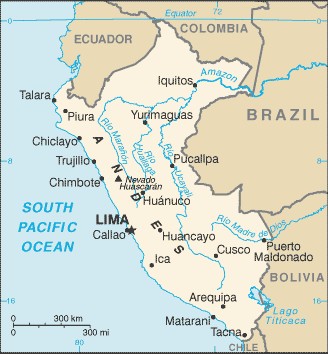
CIA Map
Geography and Politics
-Location: Western South America, bordering the South Pacific Ocean, between Chile and Ecuador
-Area size: 1,285,220 sq km
-Capital: Lima
-Geographical notes: Peru share its borders with five South American countries: Ecuador, Colombia, Brazil, Bolivia and Chile. To the South the country shares control of Lago Titicaca, world's highest navigable lake, with Bolivia. A remote slope of Nevado Mismi, a 5,316 m peak in the southern Andes, is the ultimate source of the Amazon River. Natural hazards include earthquakes, flooding and severe droughts (often related to weather changes brought by El Niño current), landslides, and mild volcanic activity.
People
-Population: 28,674,757 (July 2007 est.)
-Ethnic groups : Amerindian 45%, mestizo (mixed Amerindian and white) 37%, white 15%, black, Japanese, Chinese, and other 3%
-Religion: Roman Catholic 81%, Seventh Day Adventist 1.4%, other Christian 0.7%, other 0.6%, unspecified or none 16.3% (2003 est.)
-Language: Spanish (official), Quechua (official), Aymara, and a large number of Amazonian languages.
UNDP Human Development Index (2004)
-HDI Rank: 82
-Life expectancy at birth (years): 70.2
-Adult literacy rate (% ages 15 and older): 87.7
-Gender related development index rank: 67
-GDP per capita (PPP US$): 5,678
Economy (2006)
-GDP (purchasing power parity): $186.6 billion
-GDP - real growth rate : $77.14 billion
-GDP - composition by sector: agriculture: 8.5% ; industry: 26.4% ; services: 65%