Access
Local CD available at the Walter Hitschfeld Geographic Information Centre Information desk. Call number G3312 E7 C2 1999 N2 CD-ROM
Restrictions
Available to all users.
Coverage
1999. No updates scheduled as yet.
Description
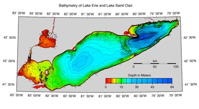
The bathymetry of Lake Erie and Lake Saint Clair consists of geological and geophysical data about the two lakes. The bathymetric data was compiled at the scale of 1:250 000 with contour intervals of 5 metres. The data is available for use in ArGIS and ArcVIew 3.x, both in vector and raster formats. In addition, ASCII and binary version of the data is available to export into other GIS programs. Images, in EPS, JPEG, and GIF formats, are available for several regions in the two lakes
System Requirements
To view and extract vector and raster data from this CD, you need ArcView 3.x or ArcGIS, available on the public workstations at the Walter Histchfeld Geographic Information Centre, EDRS, and Macdonald Campus Library electronic clasroom.
